Oregon’s Moon Country

Did you know that the NASA Apollo astronauts trained and sharpened their field geology skills in the 1960s in central Oregon?

This excellent 28-minute documentary by PBS called “Oregon’s Moon Country” describes how Oregon’s lava fields and craters were chosen as good training sites. The historical footage of the astronaut field trips in Oregon is combined with videos of their subsequent explorations on the Moon (videos from the Moon!!!) as well as interviews with astronauts, geologists, and other experts.

Apparently one astronaut, Jim Irwin, became good friends with Floyd Watson, who served as a local host in Bend, Oregon. Later, Floyd sent Jim a tiny sliver of Oregon lava and asked him to take it to the moon, and Jim Irwin did (!). (I find this story a little hard to believe.)

I look forward to the chance to visit some of these sites myself – including Fort Rock (a ring of tuff):

and Newberry National Volcanic Monument:


You can learn some more about the Newberry sights with this virtual tour. The area seems to be closed for the season, but it could be a great place to visit next spring!

Volcanoes in Guatemala

I recently visited Guatemala as a volunteer with Librarians Without Borders. We first visited the city of Xela (also known as Quetzaltenango), which is colorful and vibrant. We toured the central market, the municipal building/palace (fascinating history), the lone public library, and other sights. One thing we did not get to visit up close is the massive volcano that looms over the town.

Santa María is a breathtaking sight whenever it deigns to be seen. (Much of the time it is shrouded in cloud.) It has been active for the past 30,000 years and last erupted in 2009. It had a dramatic eruption + earthquake in 1902 that was the third largest eruption of the 20th century that dropped volcanic ash as far away as San Francisco (!).

Xela is at 7600′ above sea level, and Santa María rises another 5000′ up!

Here’s what it looks like from Xela:

And here’s what the south (active) side can be like (per Wikipedia):

We then traveled on to Panajachel (a cute touristy town on the shore of Lake Atitlán), where there are three more huge volcanoes – Toliman, Atitlán, and San Pedro. And then on to Antigua, with its own collection (Volcán de Agua, Volcán de Fuego, and Acatenango). In all, Guatemala has 33 volcanoes. Ring of Fire indeed!

Flying to Twentynine Palms

On April 1, I took my friend Vali for her first flight in a Cessna 172. Vali is a geologist who does a lot of field work in the Joshua Tree area, so we decided to fly to the Twentynine Palms airport (KTNP) which would give us some great aerial views of places she already knows well from the ground.

This was a good chance for me to do some more flying outside of the L.A. Basin. I’ve been working on trying to visit all of the L.A. airports and have now visited 17 of 26 (!). But it’s good to get some longer flights in and more experience with new locations.


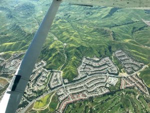
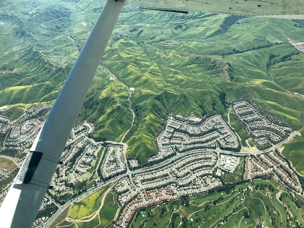
Chino Hills with spring green and yellow flower fields

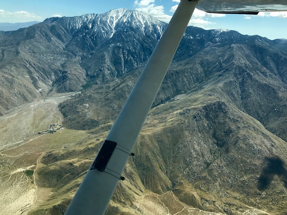
Starting from El Monte, we flew southeast to the Paradise VOR (PDZ), then east through the Banning pass at 7500′. That’s high enough to have some options for landing, but still below the mountain peaks to the north and south, yielding some dramatic views.


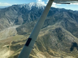
Mt. San Jacinto, south of the Banning Pass

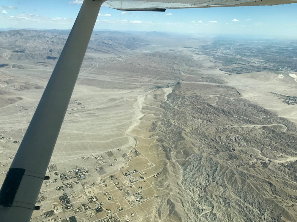
We also got a good view of the San Andreas Fault, just east of Palm Springs.
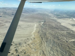

San Andreas Fault

We continued on to the Palm Springs VOR (PSP), then turned northeast to head to Twentynine Palms.

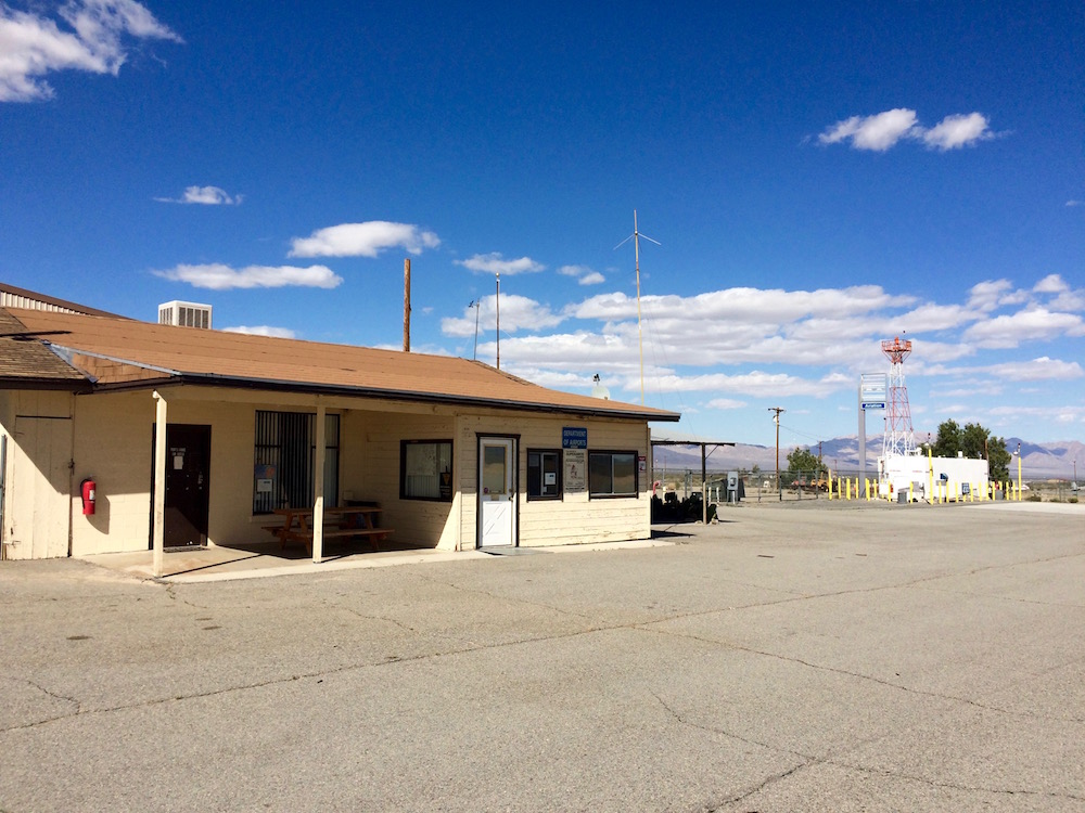
At TNP, we found a cute little pilot’s lounge stocked with water, sodas, and snacks (honor system to pay for fridge items). It also has a microwave and a bathroom. Great place to have our picnic lunch!


TNP pilot’s lounge

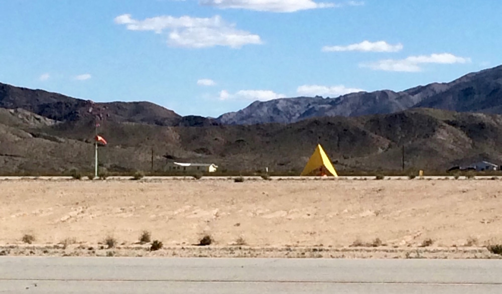
TNP has the largest and most visible wind tetrahedron I’ve ever seen. It looks like a huge yellow tent and easily spins around to show the current wind direction. Next to it, the windsock looks small and ineffective.


Windsock and wind tetrahedron at TNP

TNP has runway options for north-south or east-west winds. The larger and more improved runway runs east-west, but the winds at the time of our visit were coming from the north, so we took the smaller one. That meant flying downwind south straight at the rising terrain, then turning for a left base entry to runway 35. It’s 3800′ long, which is plenty, but only 50′ wide, compared to 5500′ x 75′ for the more commonly used runway 8/26.

We returned following highway 62 through the Morongo Valley and back west through the Banning Pass at 8500′. I tried to descend a few times as we got closer to the PDZ VOR, but SoCal kept me high to deconflict with traffic. You can see that we didn’t actually reach the VOR but instead did some navigation north around it – SoCal gave us vectors to avoid traffic during that period.

TNP track
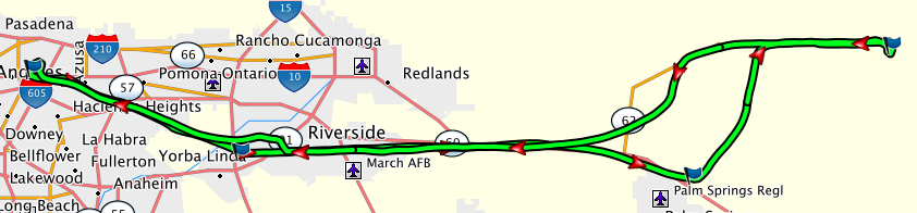
Flight track (click to enlarge).

Both flights were great! We got to see some great terrain and to visit a new airport. It took us about 1.25 hours each way, with a headwind on the way east and a tailwind coming back. It wasn’t a crystal clear day, so there was some distant haze, but still good visibility. One annoyance was that there was light turbulence throughout, which makes the ride a bit less comfortable, but nothing problematic. We overheard someone else coming through the pass who was getting 1000 fpm up- and downdrafts, and we were glad not to have anything that wild!

What is Io’s lava made of?

Jupiter’s moon Io is very active volcanically:

“A Giant plume from Io’s Tvashtar volcano composed of a sequence of five images taken by NASA’s New Horizons probe on March 1st 2007, over the course of eight minutes from 23:50 UT. The plume is 330 km high, though only its uppermost half is visible in this image, as its source lies over the moon’s limb on its far side.” (Robert Wright and Mary C. Bourke)

But what is that lava made of? What materials lie inside the moon that are being spewed out? We can’t (yet) land on Io and test its lava directly. But we can make some inferences based on remote sensing observations of the lava’s temperature. The temperature carries information about how mafic (magnesium and iron-rich) or felsic (silicon-rich) the lava may be.

The best way to test our ability to deduce composition from orbit is to do it here on Earth, where we do have the opportunity to determine the true composition by sampling the lava on the ground. Scientists Robert Wright, Lori Glaze, and Stephen M. Baloga recently reported a positive correlation between temperature observations from Earth orbit (using the Hyperion spectrometer) and ground composition observations of 13 volcanoes: “Constraints on determining the eruption style and composition of terrestrial lavas from space”. The conclusion for Io is that the lava is so hot that it is likely ultramafic: very high magnesium/iron content.

You can read more about this endeavor (and view more pictures).

Geology and Sherlock Holmes

A couple of months ago, I visited Edinburgh, Scotland, and had a glorious time exploring the local geology. One of my favorite non-geological sights in the city was the National Library of Scotland. Like the John Rylands Library in Manchester, it is not a public library, but rather one in which you can “register” to become a Reader and then do serious research, gaining access to original texts, rare manuscripts, illustrated maps, and so on. The National Library of Scotland had a wonderful exhibition, open to us non-Readers, featuring light-up displays with accoutrements associated with several famous authors, including one of my particular favorites, Isabella L. Bird, as well as Sir Arthur Conan Doyle. It occurred to me that I’d never actually read anything by Sir Arthur Conan Doyle. Back home, one day I came across this commentary on Sherlock Holmes as a forensic geologist, and all the pieces clicked together. Geology, Scotland, and Holmes—I had to sample one of those stories!

I decided to read “A Study in Scarlet” (published 1887, full text here, thank you Project Gutenberg), which is not only the first Holmes story that Doyle wrote, but also the one referenced in the context of geology. In it, Watson after meeting Holmes notes down his knowledge of geology as “Practical, but limited. Tells at a glance different soils from each other. After walks has shown me splashes upon his trousers, and told me by their colour and consistence in what part of London he had received them.” Like Andrew Alden, author of the commentary I mentioned above, I was taken by Doyle’s choice of Utah as the setting for the story behind the London murder that is unraveled by Holmes in A Study in Scarlet. His characterization of Mormons and their culture in the early settling of Utah is, um, colorful, but so is his depiction of the wide fertile valleys the settlers were so grateful to find, and the bitter steep canyons that surrounded the area. I waited for more geology to take an active role in the story, but alas.

The story itself is amusing and captivating, with a clever mystery to solve that is, happily, all explained in the end. It’s not a mystery that the reader is seriously meant to be able to solve independently, as some crucial bits of information are later revealed as being in Holmes’s possession and not available to the reader; but it is still entertaining to watch Holmes work, and above all to see what a strange, quirky, and moody character he was. (In 1891, Doyle wrote to his mother, “I think of slaying Holmes … and winding him up for good and all. He takes my mind from better things.”) I also learned a new word: jarvey (British slang for a cabdriver).

Overall, what perhaps connects Holmes most strongly to geology is his emphasis on reasoning “analytically”, by which he means working backward from evidence to deduce how things came to be the way they are now. This is equally useful in solving crimes and in understanding the long slow evolution of the rocks and structures we see around us today.

Older entries »