Cross-country flight planning
August 9th, 2015 at 3:15 pm (Flying)
Recently I planned out my first cross-country (i.e., >50 nautical miles) flight, from El Monte to Banning. The flight was done with my instructor along, but I was in charge of the planning. If this were a road trip in the car, here’s how it would have gone:
First, you consider weight and balance. You weigh each of the people going on the trip and use an Excel spreadsheet to calculate the car’s center of gravity (CG) based on each passenger’s weight and which seat they’re in, along with the weight of a full tank of gas and its position in the car and any luggage in the trunk. You look up the resulting CG in the car manual and find that the car is too tail-heavy, so Uncle Bert needs to sit up front instead of the back, and you decide to only to add 8 gallons when you get fuel instead of 12.
Next you decide on your course. You decide to take Interstate 10 west; pretty straightforward. But that’s only the beginning. You need to decide if 8 gallons is enough to get you there, so you specify the speed you plan to drive (70 mph) and your expected fuel burn (74.6 miles at 40 mpg = 1.9 gallons). Pretty good, except you need to include fuel to reach a viable alternate destination (more on that in a bit) and a 30-minute reserve (what if you get lost and end up driving in circles for a while?)… even though the total expected driving time is only an hour.
You don’t want to run into traffic coming the other direction, so you specify that you will drive in the right-hand set of lanes, and possibly exactly which lane you will use for each section of the route. The freeway is invisible, so you calculate the compass headings you’ll need to follow to stay on track, and you pick out visual confirmation markers about every 20 miles, such as the Covina Ikea, the Ontario airport, and Citrus Plaza in Redlands. You mark these on your roadmap along with how much time you expect it to take you to get to each one and how much gas you’ll burn before each one.
In case there is some reason that you cannot reach Banning, such as a road closure or major earthquake, you pick an alternate destination so that you won’t have to find it in the midst of “oh no!”. There aren’t many choices, since you are only allowed to park at about 30 different locations in the entire Los Angeles basin, but you settle on Redlands and confirm that you can get there within your 8-gallon total, and that they have gas available, should you need more for the return trip.
Now your plan needs to be matched against actual weather and road conditions. You request a weather briefing which informs you that the winds on the freeway are from 250 at 10 knots, so you tweak your timing and fuel burn estimates accordingly. This is southern California, so there isn’t a lot going on weather-wise, but you are still informed of “mountain obscuration” in the hills due to low-lying clouds and a basin-wide low-pressure area. Happily, there are no Temporary Driving Restrictions on your route, such as Obama visiting Ontario, in which case you would have had to select a different route and start over, or go through extra steps to get approval to drive through.
During the flight, you hold all of your flight plan details clipped to a kneeboard, and between glances at the road, speedometer, fuel gauge, map, and other traffic, you carefully note down your actual progress versus your planned progress. If it takes you significantly longer than expected to reach a waypoint, perhaps due to an unexpectedly strong headwind, you may consider diverting to your alternate destination.
You are also maintaining radio contact with SoCal controllers along the way, so you are listening with half an ear to the radio chatter in case your name comes up along with “Traffic at 2 o’clock, black sedan slowing to 50 mph” so you can avoid it and confirm, “Traffic in sight.” This is challenging since your car’s brakes don’t work on the freeway, so all you can do is speed up, turn, or let off the gas pedal and coast. The SoCal controllers keep tossing you along their bucket brigade, causing you to tune your radio to a new frequency with a new controller every 5-10 minutes. They may also suddenly instruct you to “Switch to lane 4” or “Reduce speed to 65 mph”, with which you scramble to comply.
Simultaneously, you are constantly scanning for possible emergency stopping points. The engine could die. The timing belt could break. The oil could dry up, a tire could fall off, the engine could catch on fire! You need to be ready! As you’re driving, you note every off-ramp and wide shoulder that could accommodate your car in an emergency. You never know.
Because the freeway is invisible, it has effects on your car that you can’t anticipate, only react to. Invisible potholes and bumps jolt you down or up unexpectedly. The location of the freeway moves up and down with the current atmospheric pressure, so you periodically tweak your altimeter with an updated setting announced by the SoCal controllers so that you can find the road again.
There are no bathroom breaks.
(For longer flights, you would pre-plan a landing at an intermediate airport as part of your flight plan that would allow you to stretch your legs, use the restroom, and eat food, as needed.)
All that planning and effort gets you near your destination, a large parking lot. You approach on the diagonal from the northwest, calling out your intentions every minute or so in case anyone else is trying to park at the same time. You might think you would just see them, and you are vigilantly on the lookout, but at 70 mph on an invisible freeway, there’s no guarantee they’ll be where you expect. You make the final turn into the parking lot and then begin slowing to attempt to park. This is non-trivial, because you are trying to figure out how to align the invisible freeway with the very visible parking lot, at precisely the right speed and angle, and since the brakes don’t work, all you can do is fiddle with the gas pedal or pop the trunk to increase drag. You roll in to a nice stop and wipe the sweat off your forehead.
Then you turn the car around and do the same thing back again.
I’m happy to report that we did the flight from EMT to BNG and back just fine. It took about 40 minutes each way — slightly longer coming back because, indeed, the wind was from the west. We had plenty of fuel, burning about 10 gallons with tanks that hold 38. The CG was fine, the morning clouds burned off in time for us to leave, I was able to find the visual markers, and I talked to all the controllers, sometimes with some very welcome coaching.
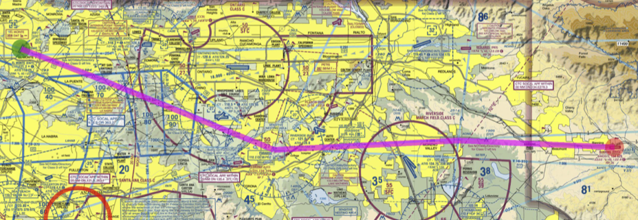
Here’s my flight plan on the chart. It’s a little hard to see, but the course is KEMT -> PIRRO -> PDZ -> ACINS -> KBNG. It’s almost exactly 60 nm. It stays under the LAX Bravo airspace, and at 5500′ it is above the ONT airspace and skims the top of the RIV airspace — but since we were talking to SoCal, we were allowed in. On the way back, we were at 4500′ but again had flight following from SoCal so were allowed through RIV and ONT airspace. Fun!
jim said,
August 9, 2015 at 3:28 pm
Nicely done! I love the analogy to the “Black sedan” at 2 o’clock.
Kiri said,
August 9, 2015 at 8:08 pm
It sure makes you think about how easily and trivially we jump in the car to drive somewhere! We just follow the road (or the GPS voice). We don’t worry about finding a place to park, or finding gas, or whether there will be gas at all. We don’t worry about the weight of the load and its effect on MPG (unless we are super-environmentally-conscious). It’s so simple!