March 13th, 2023 at 3:23 pm (Vocabulary)
Recently I came across the word “parergon”, which was new to me. When I looked it up, I learned that it refers to “a piece of work that is supplementary to or a byproduct of a larger work” (Oxford) or “a supplementary issue or embellishment” (wikipedia). It is something (ornament or frame for art, appendix to a book, etc.) that supplements the “ergon”, the primary work. I hadn’t encountered “ergon” either, but hey! It rings a bell from “ergonomics”, which refers to “the study of people’s efficiency in their working environment” (Oxford again). The common root “erg” refers to work. Nifty!
Parergon apparently can also refer to an activity outside of your main occupation (hobby, presumably, or what today would be called a “side hustle” if you’re making money from it). May we all have many parerga – it’s not all about the ergon!
Comments
March 4th, 2023 at 11:16 am (Flying, Games)
I may have invented a new sport!
Airplane instrument approaches to airports allow you to fly safely through clouds (or in the dark) without running into terrain or obstacles. They specify the path to fly and the minimum altitude for each segment. Individual obstacles (hills, towers, etc.) are also charted as an additional warning for things to avoid.
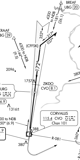
 One example is the ILS approach to runway 17 at the Corvallis (KCVO) airport. An excerpt is shown at right. You fly along the thick black line from top-to-bottom on this chart (with a heading of 172 degrees) to get to runway 17, which is near the icon marked with the “CVO” bubble (this is actually the VOR but it’s close to the approach end of RW 17).
If you look near the point marked “ZIKDO”, you can see a little pointy icon with “1757” next to it. This indicates an obstacle (tower) that sticks up to 1757 feet above sea level. The procedure specifies that your airplane should be no lower than 2800′ here, and the obstacle shows you exactly why. It’s comforting to know that you have 1000′ of clearance above the highest obstacle as you’re flying along at 100 mph without being able to see the ground.
I have flown this approach several times, and I’ve always either had my foggles on or been in the clouds, so I’d never actually seen the obstacle. It was more of a theoretical entity.
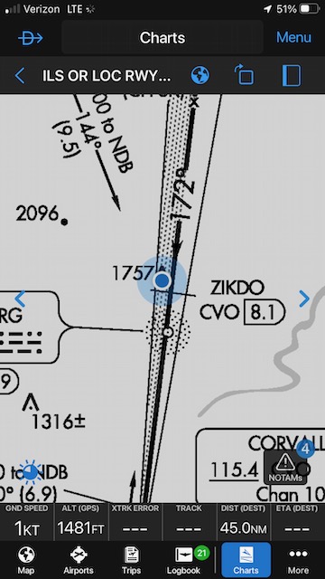
 The other day I was out for a hike and realized that the path I was on went right under the ILS 17 approach course. In fact, as I hiked up a hill, I realized that I might be approaching whatever that tall obstacle must be. I pulled up my Garmin Pilot app (generally used when I’m flying, not hiking) and was able to navigate to the ground location of the obstacle near ZIKDO! The blue dot shows my location. The app reports I’m standing at 1481′, so (depending how accurate that is), the tower would be about 275′ tall.
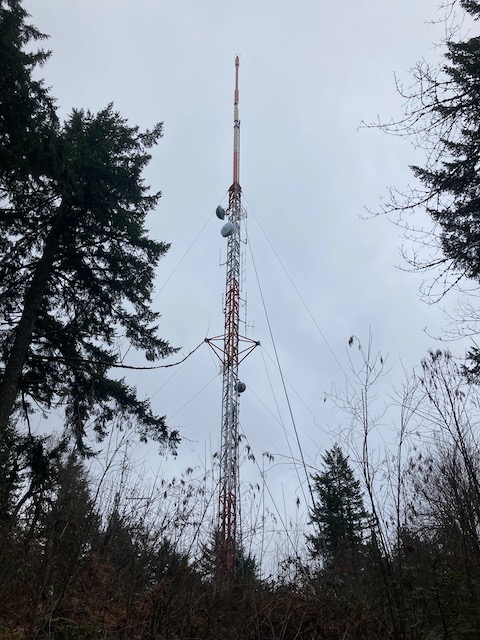
And here is what I found: an impressively tall tower sticking up on top of the hill and certainly not something I’d like to have in close proximity to my airplane:
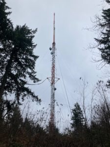
It was so cool to see it with my own eyes! Locating the obstacle felt a little like an aviation-themed geocaching exercise :) There was no tangible treasure to be found, but now the instrument approach procedure chart feels a little more “grounded”, and I can appreciate all over again the work that goes into formulating these approaches to keep us safe. There’s more to find on this chart alone! I already know the one at 388′ just north of the airport (it’s a water tower, very cool). Maybe sometime I’ll make my way to the tower at 1316′, the hill/mountain at 2096′, or the tower indicated at 380′ south of the airport. Here’s to finding more aero-obstacles!
Comments