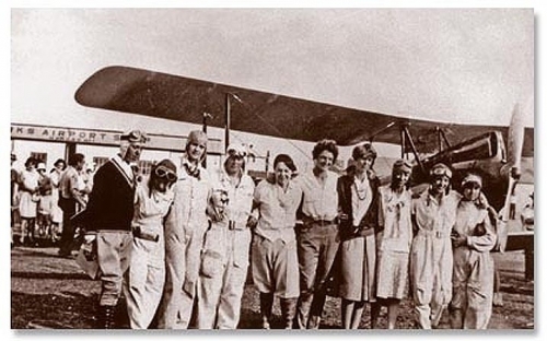
 On August 18, I participated in a special event to commemorate the 90th anniversary of the first all-women’s air race in 1929. That historic event featured 20 women pilots (including Amelia Earhart and Louise Thaden) and was a challenging nine-day race from Santa Monica, CA, to Cleveland, OH.
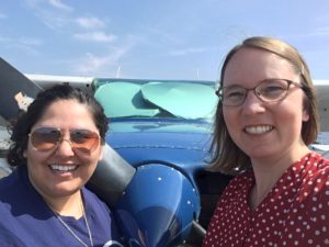
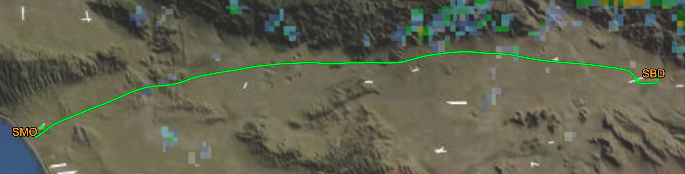
Here in 2019, I gathered along with 13 other pilots to fly the same first leg of the 1929 event, from Santa Monica to San Bernardino, in an event sponsored by the Los Angeles 99s. It’s a distance of about 70 miles. I was flying a Cessna 172 with 160-hp engine – a solid plane but not exactly a racing machine. I’ve been to Santa Monica several times, but I’d only flown to San Bernardino once, three years before. I plotted a route over Dodger Stadium and north along the foothills before turning south at the end for San Bernardino. I picked an altitude of 3500′ since I figured that, for this relatively short flight, any benefit gained by flying at 5500′ would not offset the cost of climbing, especially in this particular plane.
We had a delayed start just getting to Santa Monica due to a lingering marine layer, as often happens this time of year. My co-pilot Tara and I were ready to leave El Monte to fly to Santa Monica and start the race, but we had to sit around obsessively checking weather reports until I judged it safe to proceed. It worked out great – when we reached Santa Monica, the clouds were still there, but just high enough that I could fly my typical altitude and maintain a safe separation. We landed and joined the other pilots prior to the official departure.
Period attire was encouraged, and the other pilots were decked out in flying suits, leather caps, scarves, and goggles. Wow! I didn’t have anything that cool, so I wore a polka-dot dress that could almost pass for 1920s. I will say that flying in a dress is rather inconvenient – I had to flight with my kneeboard to get it positioned 🙂
Departing Santa Monica was a bit of a scrum. Several racing planes had already departed, but the radio traffic on ground control was still very busy with multiple requests for flight following to San Bernardino mixed in with regular Santa Monica traffic. After a long time holding, I finally got to taxi onto the runway to “line up and wait” and then we were off! Tara had the stopwatch to time our departure and landing.
I was able to follow my planned route exactly. I flew a lot faster than I normally do. We were making excellent time, about 130 mph ground speed (I think we were also favored by a tailwind). I monitored the engine temperature and other instruments carefully to ensure I wasn’t stressing the plane. It performed like a champ – I was even able to lean the mixture without it getting too hot. I maintained speed approaching San Bernardino. They instructed us to cross over midfield and enter the left downwind for runway 24. I was eying the runway and debating whether to request a short approach, but then noticed another plane on final and we were cleared #2, so no short approach. I turned in sequence, made a precise short-field landing, and was able to exit on the first taxiway, and when the wheels came to stop, so did the stopwatch! Our time from takeoff to landing was 40 minutes and 34 seconds.
It was fun being welcomed in to the FBO with ground crew directing us with hand signals – that always feels like special treatment. At the FBO, we had a lovely lunch and then were treated to a performance of songs from a musical that was written a while back about that first 1929 race! You can read more about the event in KCRW’s article.
 Finally, there was the awards ceremony… during which we were delighted to learn that we received second place! We didn’t have the second-best time overall, but there is some complex handicapping math applied to normalize for different types of planes and engines, and apparently we did very well given the equipment we had. Hooray!
I flew us back to El Monte at a more leisurely pace. It was clear skies and easy flying back. I finished the day with a third superbly executed landing – super gentle and well controlled. It’s one thing to get somewhere quickly, but also important to finesse the landing at the end!
 My new house in Oregon is located within the “Madrone Estates”. That’s right, I apparently now own an Estate! Ha ha!