Be a citizen scientist for nature

I recently discovered iNaturalist, which is a website and smartphone app that encourages you to collect observations of plants, animals, and insects. By recording when and where they were observed, you contribute to the store of data about these organisms. This place must be every biologist’s dream come true! Data for free!

They’ve put some thought into how to ensure high quality data. When you log an observation of, say, a ladybug, you can simply record it as “insect” and let others refine it, or be as specific as you feel confident to narrow down its precise species. The crowd of other users will review your tag and vote for it as correct or make corrections. When an organism is pinned down at the species level, that observation becomes “research grade.”

So far I have contributed observations of a praying mantis (needs review) and a raccoon (research grade!). When you log an observation and connect it with a species, you also get to see a map of where else that species has been seen.

You can also “subscribe” to get updates whenever a particular organism of interest is spotted! I signed up for praying mantises (mantis religiosa), spiny lizards (at the genus level (sceloporus), not a species), and collared lizards (family crotaphytidae – a beautiful creature from my childhood). Just today I’ve seen a bunch of new lizard observations (one dead). I’m looking forward to more. (I’m also being exposed to the Latin names for things. What fun!)

Another cool feature is that you can browse an area (say, where you are currently standing) to see what has been observed there.` You can also join specific research “projects” and contribute your matching observations (e.g., a project might specify that they want only pictures of reptiles observed in southern California).

I love to see well constructed efforts to engage people in the process of science. This one seems particularly compelling and enjoyable to use.

Discarding books from the library

I have a new volunteer role at the Monrovia Public Library – helping them get rid of books.

I know, I know, it sounds awful. But like any other kind of possession, book clutter builds up. Books get damaged from use. New versions supersede old ones (especially in the computer software section – one book we processed was “Photoshop Elements” from 2001. Don’t worry – the Pasadena Library still has it). Some books just never circulate. Sometimes the right thing to do is to let a book go, so you free up space for new books.

The librarians have already been busy identifying which books to discard (a process called “weeding”). (Amusingly, my just-completed MLIS thesis is on weeding – specifically, how to use machine learning classifiers to help prioritize books for removal.) I was shown an entire wall of shelves in the back room where hundreds of books are already in pre-discard limbo.

I was shown how to select one of those books, then edit the library’s catalog to remove it, and then remove the book from the OCLC (Online Computer Library Center). Among other things, the OCLC maintains a central database of library holdings, which enables you to search for an item once and find out which libraries have it, ordered by proximity to your location. Try it out: Search WorldCat.

I’m impressed and a little awed that the library would entrust me with making edits (deletions) to their catalog and their entries in OCLC. However, I’m nearly done with my MLIS, so I’m almost fully qualified to be a librarian myself, I guess! The class I took on Cataloging is suddenly very relevant; we worked with library catalog entries and strategies for a semester, and the terminology and tools are familiar.

One final challenge is that the library is switching to new catalog software on June 13, so the removal procedure will change. More significantly, that date coincides with the start of our Summer Reading Program, at which point library circulation sky-rockets. The patrons are going to have some growing pains, no doubt, and so will the staff. Fun times ahead!

Flying to Flabob with a friend!

Today I got to fly with another pilot, Sara. We’ve been trying to get out to Hemet-Ryan for weeks, but the weather just won’t cooperate. Yet again, today, the clouds were too low to make that possible. However, we were able to fly out to Flabob (KRIR) and Corona (KAJO).

I took the helm to fly us out to Flabob. The ceiling was reported around 3500-4600 AGL, but when we got up it seemed a bit lower than that. I settled on 2800′ MSL. SoCal directed us around some traffic, and we got a smattering of rain, but we had a nice view while flying east.

Mt. RubidouxFlabob is certainly a challenging place to land. There’s a big hill/mountain (Mount Rubidoux) that squats just southeast of the runway, right about where you want to be when you’re getting ready to land on runway 24. This biases you towards turning (left) base a bit early. I ended up coming in high on my first attempt to land and doing a go-around. The second time worked out fine, but it takes some mental effort to intentionally fly at a mountain at 80 mph. When it was Sara’s turn, she figured out that by flying a diagonal base leg you can avoid the mountain yet still get a longer, more normal final approach. Brilliant!

At Flabob, we stopped and switched pilots. Sara got in, did a loop around the pattern, and then flew us to Corona. We got a transition through Riverside’s airspace and then cruised over to Corona, whose runway is the same length as Flabob’s but in rather nicer condition, and much wider. There are some beautiful marshlands north of Corona where birds nest.

AJO marshlandAfter landing at Corona, Sara took off again and we got a transition from Chino airport and then flight following to head back to El Monte. Spotting El Monte was difficult due to the low clouds and grey sky, but we got in just fine. Overall, several great landings by Sara!

It was really great to fly with another pilot! We helped each other out with radio communications, double-checking frequencies, and discussing airport approach strategies. Sara has a lot more experience than I do, and I can learn a lot from her (already got some great tips)!

Below is the track of our flight, starting from El Monte on the left and heading to Flabob (KRIR), then Corona (KAJO), then back to El Monte.

RIR - AJO - route

That makes 9 out of 26 L.A. airports for me!

Flying to Redlands

The weather briefing for my flight today had an unusual feature: an upcoming TFR (Temporary Flight Restriction) over my destination, the Redlands airport. It seems that Redlands is hosting an airshow this weekend, and in addition to the TFR covering the airshow itself, they blocked out an hour today from 3 to 4 p.m., possibly for the airshow pilots to practice.

Some calculations later, I determined that I should be able to get to the airport, pre-flight my plane, and fly to Redlands and back before the TFR kicked in. I was off!

(Why Redlands? It’s one of the five airports in the upcoming Flabob Poker Run. I’m doing advance scouting!)

Santa Fe Dam
I got flight following from El Monte and climbed to 5500′ to head east to Redlands. This is not a picture of Redlands. It’s a picture of the Santa Fe Dam area, which I flew past. It’s pretty awesome – note the stepped dams on the left to block debris flows from the canyon. Plus, golf course. I stayed north of the 210 freeway, then swung down behind the San Bernardino airport to enter the right pattern for runway 26 on the 45.

As I was about to turn base, I noticed a helicopter about to land. A few seconds later, someone on the radio said “All aircraft, use the radio for safety” which may or may not have been directed at the helicopter. I had been announcing my position, but hadn’t heard anything from a helicopter. I gave it some extra time and by the time I turned final, it was already out of sight.

On the ground, it was pretty busy at Redlands, with carts, trucks, and planes moving around in preparation for the airshow. I spotted a very pretty red biplane! But it was already 2:30 p.m. and I wanted to be sure to be out of there before the TFR kicked in at 3. I took off back to the west, turned sharply north to stay out of San Bernardino’s airspace, and got flight following back to El Monte at 4500′. It was fun cruising through Ontario’s airspace!

Here is my route today. The more northerly track was me headed east to Redlands, and the southerly one is me coming back.

Redlands route

Back at El Monte, I still had energy and time left, so I did some pattern work. I worked on my left traffic patterns, which tend to be weak (we’re used to right traffic at El Monte, and also at Redlands!). I worked on improving my base to final turn. I also made two very nice short-field landings despite the wind, which was gusting from 8 to 14 knots and also swinging around between 170 and 220 degrees. Great flying day!

Here is my updated airport map. I’ve now been to 8 of 26 L.A. airports since getting my license!

2016-05-13-airport-map

Flying to Catalina Island

Recently I had the opportunity to fly from El Monte to Catalina Island (KAVX). This is one of two local airports for which our club requires that you first go with an instructor, due to special challenges. (The other airport is Big Bear, KL35). Catalina is a beautiful island not far off the coast (~30 nm) that is 88% controlled by the Catalina Conservancy. The airport is privately owned and, unlike most of the L.A.-area airports, charges a landing fee ($25).

Getting from El Monte to Catalina poses the following challenges:

  • Navigate around the LAX class Bravo airspace. (Flight following is your friend! Except when they are too busy.)
  • Cross over the water. Bring life jackets. Study ditching procedures. Try not to freak out with imagined scenarios.
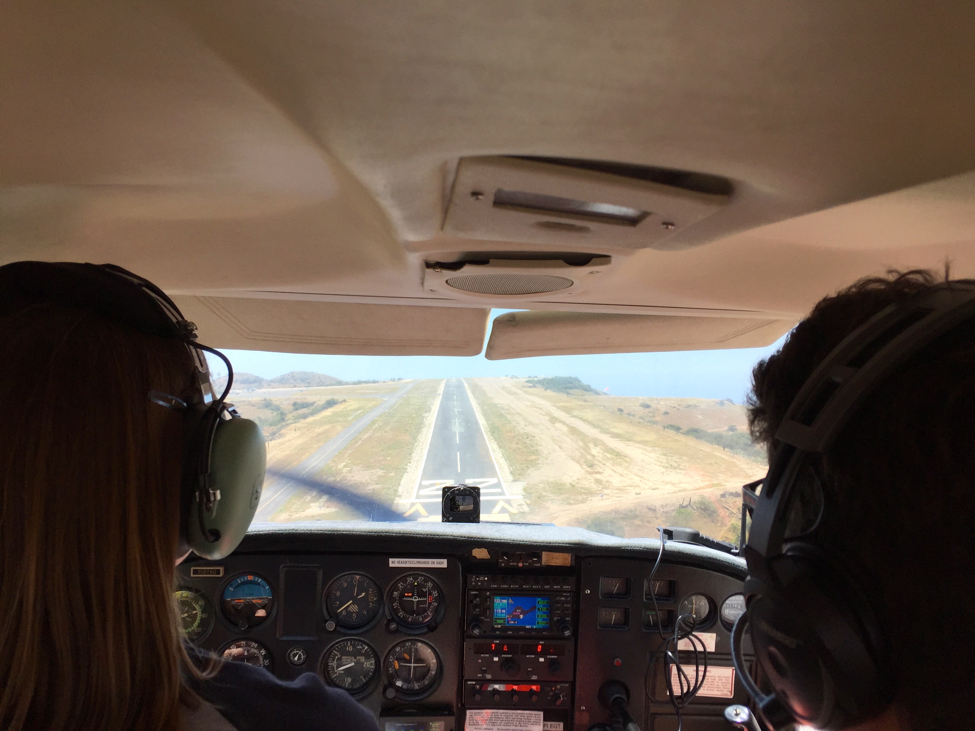
  • Land on what looks like a misplaced chunk of runway stuck on top of a mountain. Don’t get low on final approach and crash like this Cessna 172 did, 9 days before our visit. The tail of the airplane is sitting near the west end of the runway (moved there from the crash site) – a grim reminder to take this seriously. Be ready to go around.

My instructor, David Werntz, wrote up an excellent guide to help you prepare for flying to Catalina. He’s not kidding about the poor runway condition! It’s not just bumpy, but it’s full of holes and little piles of debris. It looks like someone took a pickaxe to it all along the length. It definitely calls for soft-field takeoff technique to save your nosewheel. (Maybe soft-field landing as well!) Even better, the runway is peaked in the middle, so you take off (and land) on a 2-degree slope, which believe me does noticeable things to a Cessna’s acceleration. It also gives this awful illusion from the ground that the runway is going to end halfway along its length, since you can’t see over the peak during takeoff.

The trip out went smoothly. We aimed for Fullerton and climbed to 3500′, staying under the 4000′ LAX Bravo. At Fullerton, we turned southwest and climbed to 4500′ and headed out to sea. I could tell whenever my instructor got bored, because he’d ask, “Okay, where would you land if the engine quit … NOW?” When we got far enough away from land to preclude gliding back, he’d point out ships in the water to land nearby to minimize rescue time. “Ferries are good; they’re maneuverable and they have rescue boats,” he said. “Sailboats are bad.”
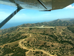
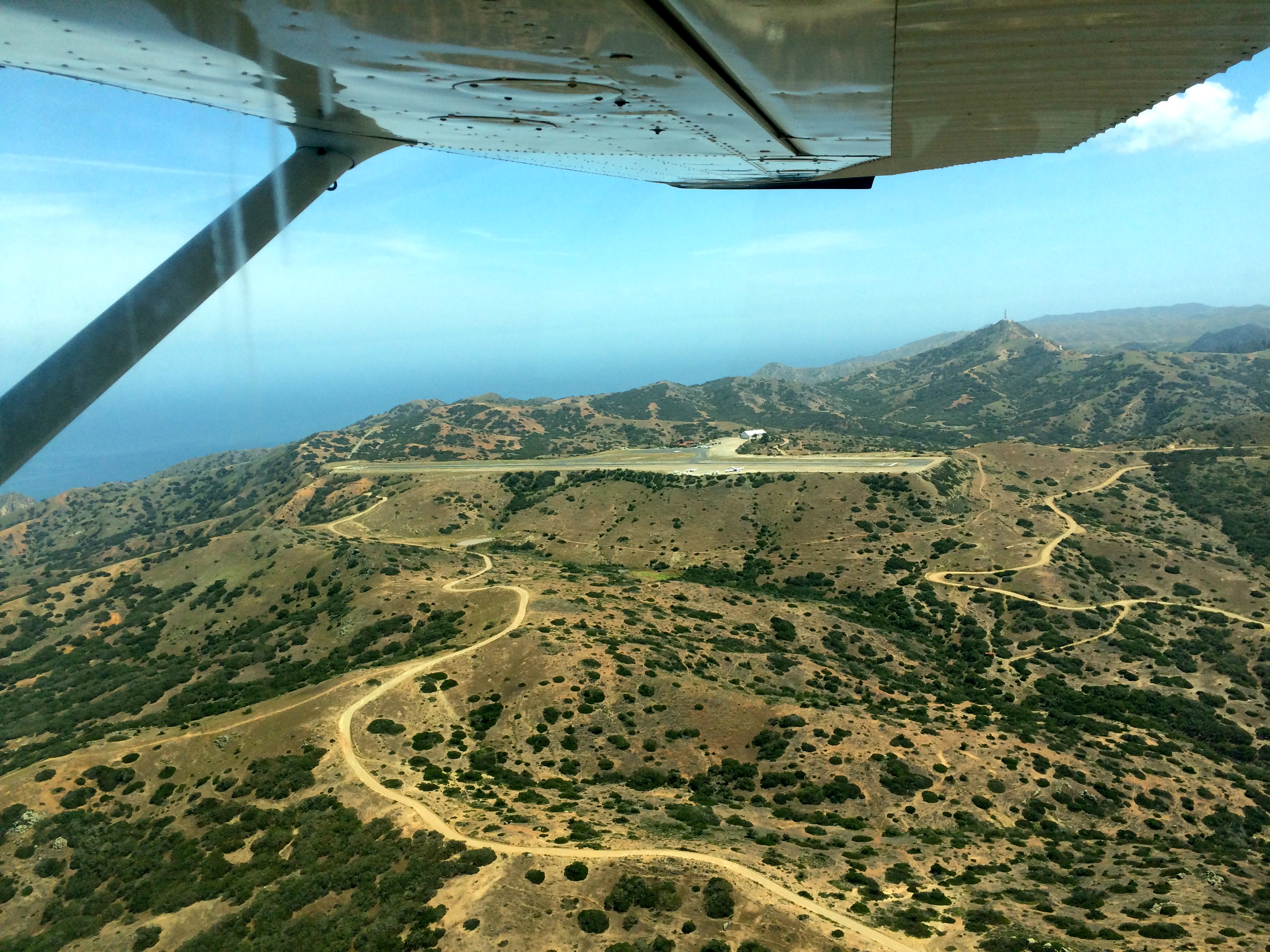
Catalina

Catalina runway
There it is, KAVX!

We flew to Two Harbors, then turned south to enter the pattern for runway 22. Delightfully, the airport was nearly deserted. I understand that on weekends it can get very busy. I got to do three landings (full stop), and we had lunch at the cafe.

Runway 22
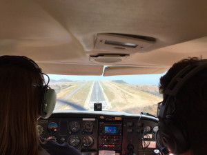
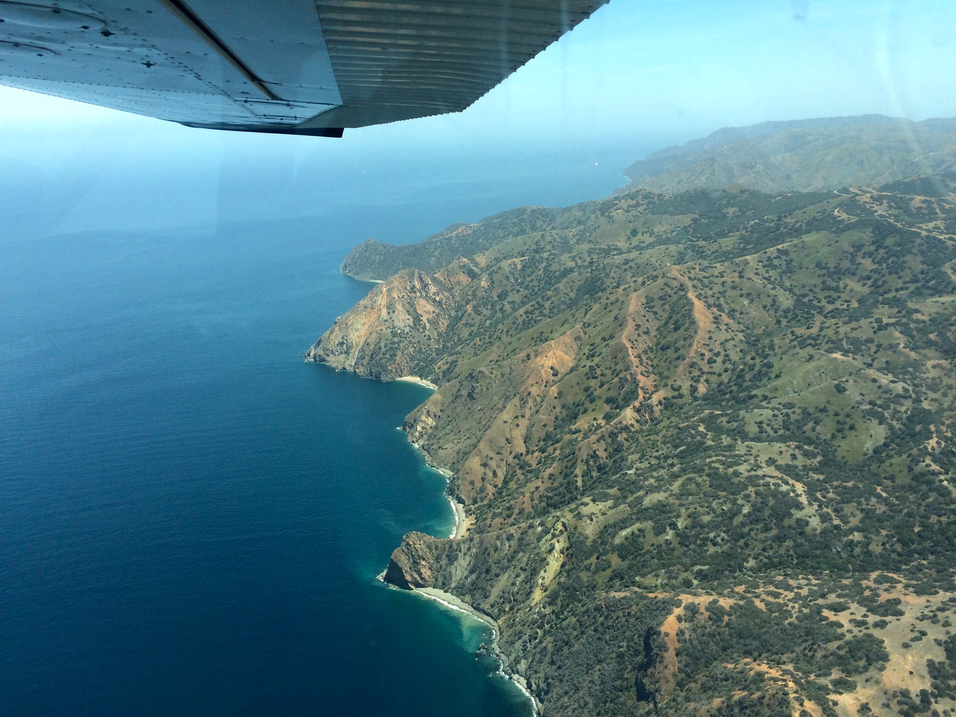
This view obscures the cliff below us. But steady on!

Unfortunately, we ended up with insufficient time for Manuel to get his three landings in! But thankfully, he flew us back home.

Long Beach
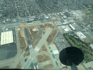
Crossing over Long Beach airport. Note the big red X on runway 16R.
Don’t land there!

That was a far more challenging transit than on the way out. The first SoCal approach controller he hailed refused to give us flight following (too busy). A controller on a different frequency was willing to take us, and after a few comments to Southwest XXX and Delta YYY, he spent the rest of our flight (transiting under the Bravo) devoted just to us. For some reason, we had constant traffic alerts, one after another, mostly helicopters. Coming in to El Monte, the controller directed us to make a right 360 for spacing (someone ahead of us), and then seemed to forget we were there. After prompting, he told us to make left traffic for runway 19. Suddenly, Manuel spotted a helicopter at our altitude just ahead, and called it out to the tower controller, who seemed a bit befuddled. He cleared us to land behind a Diamondstar, so we had to turn inside the helicopter, which was further out and moving slower. It all worked out, but it was the closest I’d been to a helicopter in the air. Go Manuel!
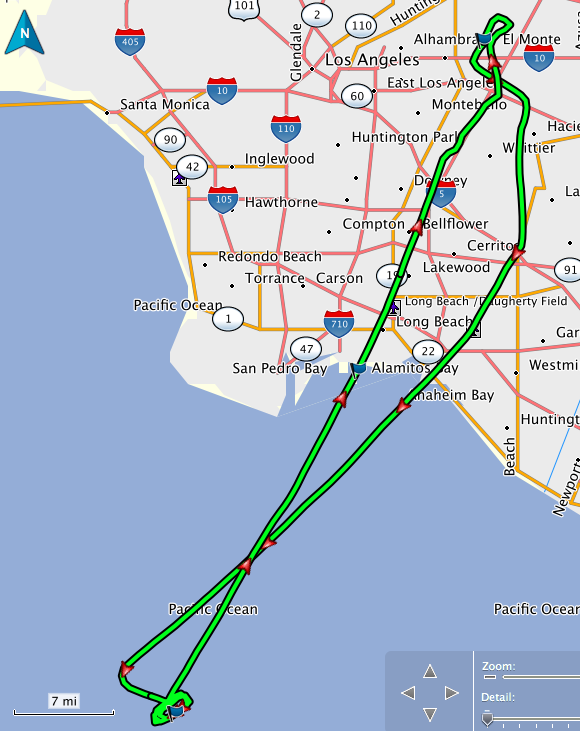
Here’s our route:

Catalina route

Given that trip, I am now certified by the club to fly their planes to Catalina. I’m thinking I could use some more practice there though! We might go out to do it again and let Manuel get his landings in :)

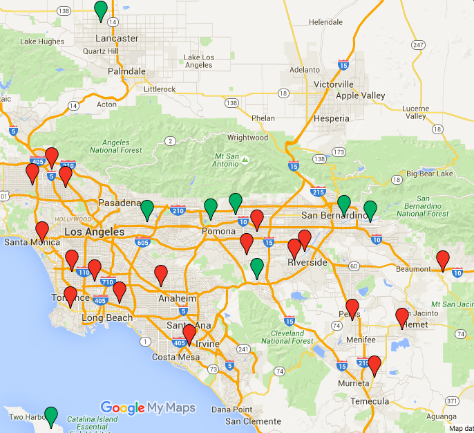
Here’s my updated map of L.A. airports I’ve visited since getting my license (green) and those yet to be visited (red):

« Newer entries · Older entries »